The need for MPAs in the Antarctic
By Haley Kilgour, SRC Intern
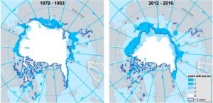
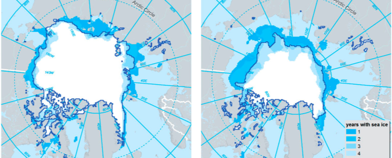
With global climate change in effect the Arctic ice sheet has been losing area and has gone from 7.5 million km^2 in 1979 to 4 million km^2 in 2016 (Figure 1). The loss of ice coverage is detrimental to many species, but on the other hand opens up areas to new fishing grounds, oil and gas deposits, deep sea minerals, and shorter shipping routes that were previously inaccessible. While economically it is beneficial to exploit these now accessible resources, it is also necessary to designate Marine Protected Areas (MPAs) to preserve habitat and biodiversity.

Year round see ice cover for the periods of 1979-1984 and 2012-2016.
Geomorphic features such as seamounts, submarine canyons, hydrothermal vents, submarine plateaus, ridges, and escarpments serve as a proxy for benthic communities and ecological processes as they are often areas of high biodiversity and important to processes such as upwelling. Harris et al looked at the distribution of geomorphic features on the sea floor to assess their current level of protection within MPAs. They also aimed to see if these features were occurring within or outside of MPAs and identify ones that were once inaccessible due to year round sea ice.
To determine their area of study, Harris et al used the average minimum sea ice coverage from 1979-1983. They looked at the years 1979-1983 and 2012-2016 (the earliest and latest time periods) to see how much of the geomorphic features are now exposed. Twenty-nine categories of features were mapped using Shuttle Radar Topography Mapping (Shuttle Radar Topography) and MPA boundaries were taken from the IUCN and UNEP-WCMC database. The program ArcGIS was then used to compute areas.
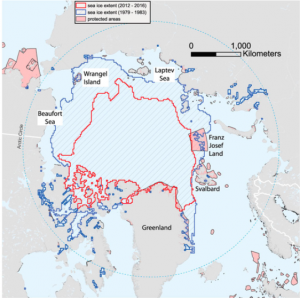
On average, 31% of all previously year round covered features in the Arctic are now in open water in September. In 1979-1983, only 2.33% of areas below year round sea ice were in MPAs, and these were mostly areas on coastal and shelf habitats (Figure 2). This lack of diversity in features that are protected means there is high potential for them to be exploited now that year round ice no longer prevents access.

MPAs within the Arctic in relation to September sea ice cover in the periods 1979-1983 and 2012-2016.
As it stands, only 2.3% of the areas used in this study are in MPAs. While this seems to pose a problem, Canada, Denmark, Russia, Norway, and the USA have signed a “Declaration concerning the regulation of unregulated high seas fishing in the central Arctic Ocean” and a moratorium. Thereby, the areas beyond national jurisdiction have a degree of protection from fishing pressure at the current time.
Current MPAs mostly cover coastlines and inner shelf regions. Abyssal plains are not covered at all and there negligible protection for slope habitats. While the current MPAs do provide a small effect, they are not representative in the standard MPA design.
There are many geomorphic features that have been left exposed and all are fragile ecosystems. Basins collect sediment and anthropogenic contaminants, making them particularly susceptible to pollution from runoff and chemicals. Submarine canyons are considered biodiversity hot spots and prime fishing grounds, making them vulnerable to degradation. Only .2% of canyons are within existing MPAs and retreating sea ice now exposes 37% of their area. Submarine canyons face particular danger because they are associated with oil and gas deposits. Plateaus are mostly unexplored worldwide and thus need further examination and protection.
These underwater geomorphic regions are high in biodiversity but are finding themselves in peril with retreating sea ice. Many of these areas are likely under rapid ecological transition as the Arctic responds to global climate change. These ecosystems are highly unexplored and sensitive. They could be lucrative economically, but are also most likely highly important for conservation. MPAs will play a major role in protecting these areas.


Leave a Reply
Want to join the discussion?Feel free to contribute!